
Strongly emphasizing the increasingly green credentials of the country, Union Minister for Environment, Forest and Climate Change, Dr. Harsh Vardhan has said that India has shown an increasing trend in the forest and tree cover, in comparison to the global trend of decreasing forest cover during the last decade.
Releasing the India State of Forest Report (ISFR) 2017 on Monday, Dr. Harsh Vardhan pointed out that India ranks among the top ten countries of the world in terms of forest area, despite the fact that none of the other 9 countries has a population density of more than 150 persons per sq km, compared to India, which has a population density of 382 persons per sq km. “India is ranked 10th in the world, with 24.4% of land area under forest and tree cover, even though it accounts for 2.4 % of the world surface area and sustains the needs of 17 % of human and 18 % livestock population”, the Minister said. He averred that despite such tremendous population and pressures of livestock on our forests, India has been able to preserve and expand its forest wealth. Dr. Harsh Vardhan added that as per the latest FAO report, India is placed 8th in the list of Top Ten nations reporting the greatest annual net gain in forest area.
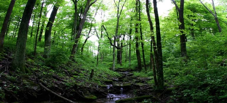
Quoting figures from the India State of Forest Report 2017, Dr. Harsh Vardhan stated that the latest assessment shows that there is an increase of 8, 021 sq km (about 80.20 million hectare) in the total forest and tree cover of the country, compared to the previous assessment in 2015. He added that the increase in the forest cover has been observed as 6,778 sq km and that of tree cover as 1, 243 sq km. “The total forest and tree cover is 24.39 per cent of the geographical area of the country”, the Minister pointed out. He also underlined the encouraging sign that much of the increase in the forest cover has been observed in Very Dense Forest (VDF), as VDF absorbs maximum carbon dioxide from the atmosphere. “The increase in forest cover in VDF is followed by increase in open forest”, the Minister said. He also pointed out that the ISFR 2017 has been prepared with the help of scientific tools.
Giving the State-wise break-up, Dr. Harsh Vardhan said that three states – Andhra Pradesh (2141 sq km), followed by Karnataka (1101 sq km) and Kerala (1043 sq km) have shown the maximum increase in forest cover. “Madhya Pradesh has the largest forest cover of 77,414 sq km in the country in terms of area, followed by Arunachal Pradesh with 66,964 sq km and Chhattisgarh (55,547 sq km). In terms of percentage of forest cover with respect to the total geographical area, Lakshadweep with (90.33 per cent) has the highest forest cover, followed by Mizoram (86.27 per cent) and Andaman & Nicobar Island (81.73 per cent)”, the Minister stated. Referring to the enormity of the task of preparing the State of Forest Report, the Minister said, “Work has already started for preparing ISFR 2019”.
Speaking on the occasion, Minister of State in MoEF&CC, Dr. Mahesh Sharma said that 18, 000 points have been physically surveyed in a scientific manner in the preparation of the report. He appealed to the society and media to help in the huge task of conserving and protecting the forests.
Addressing the gathering, Secretary, MoEF&CC, C.K Mishra underlined that economic value of the forests must be realised and forests should be used economically. He emphasised that the value of forests is more for the people living in and around forests, hence the most critical issue is for whom is this exercising being conducted. Mishra stated that forests do not exist in isolation and the benefits of the forests must be transferred to the people. He stressed that issues related to agro-forestry and degraded forests must be paid attention to.
The present assessment also reveals that 15 states/UT’s have above 33 per cent of the geographical area under forest cover. Out of these States and Union Territories, seven States/UTs namely Mizoram, Lakshadweep, Andaman & Nicobar Islands, Arunachal Pradesh, Nagaland, Meghalaya and Manipur have more than 75 per cent forest cover, while 8 states – Tripura, Goa, Sikkim, Kerala, Uttarakhand, Dadra & Nagar Haveli, Chhattisgarh and Assam have forest cover between 33 per cent to 75 per cent. About 40% per cent of the country’s forest cover is present in 9 large contiguous patches of the size of 10, 000 sq.km, or more.
As per the ISFR 2017, the total mangrove cover stands at 4,921 sq km and has shown an increase of 181 sq km. All the 12 mangrove states have shown a positive change in the mangrove cover, as compared to the last assessment. Mangrove ecosystem is rich in biodiversity and provides a number of ecological services.
The total growing stock of India’s forest and trees outside forests is estimated as 5,822.377 million cum, of which 4,218.380 million cum is inside the forests and 1,603.997 million cum outside. There is an increase of 53.990 million cum of total growing stock, as compared to the previous assessment. Out of this the increase in growing stock, there is an increase of 23.333 million cum inside the forest and 30.657 million cum outside the forest area. The total carbon stock in the country’s forest is estimated to be 7,082 million tonnes, which shows an increase of 38 million tonnes, as compared to the previous assessment.
The extent of bamboo-bearing area in the country has been estimated at 15.69 million ha. In comparison to the last assessment done in 2011, there has been an increase of 1.73 million ha in bamboo area. The growing stock of the bamboo in forest has been estimated to be 189 million tonnes. There is an increase of 19 million tonnes in the bamboo-growing stock as compared to the last assessment done in 2011. The total annual potential production of timer from trees outside forest has been estimated at 74.51 million cum. The Government has recently enacted a Bill in the Parliament for taking out bamboo from the tree category, where it is grown outside forest areas. This will encourage people to grow bamboo on private lands, which will be helpful in increasing the livelihood opportunities for farmers and also enhance the green cover and carbon stock of the country.
Director General, Forests and Special Secretary, Dr. Siddhanta Das, Additional Director General, Forests, Shri Saibal Dasgupta and senior and retired officers of Forest Survey of India were among those present on the occasion.
BACKGROUND:
The information given in the report will serve as an important tool to monitor the country’s forest resources and plan suitable scientific and policy interventions for its management. It will also serve as a useful source of information for the policy makers, planners, State Forest Departments, line agencies involved in various developmental works, academicians, civil society and others interested in natural resource conservation and management.
The India State of Forest Report 2017 is 15th such report in the series. In line with the Government of India’s vision of Digital India and the consequent need for integration of digital data sets, the Forest Survey of India has adopted the vector boundary layers of various administrative units upto districts developed by Survey of India along with digital open series topo sheets, bringing about full compatibility with the geographical areas as reported in Census, 2011. Forests play a vital role in water conservation and improve the water regime in the area. Considering the importance of water bodies in forest, FSI has assessed water bodies in forest cover for the decade 2005-2015. As per the assessment, there is an increase of 2,647 sq km in the extent of water bodies inside forest cover between 2005 to 2015.
The report contains information on forest cover, tree cover, mangrove cover, growing stock inside and outside the forest areas, carbon stock in India’s forests and forest cover in different patch size classes. Special thematic information on forest cover such as hill, tribal districts, and north eastern region has also been given separately in the report. The report for the first time contains information on decadal change in water bodies in forest during 2005-2015, forest fire, production of timber from outside forest, state wise carbon stock in different forest types and density classes.
The spatial information given in the report is based on interpretation of LISS-III data from Indian Remote Sensing satellite data (Resourcesat-II) with a spatial resolution of 23.5 meters. Satellite data for the entire country was procured from NRSC for the period October, 2015 – February, 2016. The satellite data interpretation is followed by rigorous ground truthing. In addition extensive ground data collected by field parties at more than 18000 points all over the country and information from other collateral sources are also used to improve the accuracy of the interpreted image.
Forest Survey of India (FSI) has been assessing the forest and tree resources of our country on a biennial basis since 1987. The results of the assessment are published in its biennial report titled “India State of Forest Report (ISFR)”.
ALSO READ:
Hollywood actor criticizes the US government for pulling out of the Paris climate agreement
Australia tourism industry under climate change threat – study
Trump to withdraw nomination of environmental pick Kathleen White